We start with this map (which appeared in the Economist some time ago) to see the various disputed areas involving India, Pakistan and China.

While the LOC in Kashmir is basically a result of Pakistan grabbing whatever it could in 1947-48, the borders with China are somewhat more complicated, involving treaties by various entities controlling Kashmir, the former NEFA and Tibet over the past two centuries.
There is even a small disputed area called Bara Hoti on the border between Uttarakhand and Tibet, but nothing much happens there. China claims most (but not all) of Arunachal Pradesh; the dark green part of the map is the undisputed part of that state. And Tawang was supposedly governed by Tibet until 1951 before India occupied it.
That bit about Arunachal is necessary to understand this extract from the Wikipedia article on “Extreme points of India”:
| East (disputed, administered) |
Kibithu in Anjaw district | Arunachal Pradesh | Tibet, China | 28.01744°N 97.40238°E | [4][8] |
| East (undisputed) | Near Kumki, in the Changlang district | Arunachal Pradesh | Kachin State, Myanmar | 27.12622°N 97.16712°E | [9] |
Kibithu is in the disputed part of Arunachal while Kumki is in the smaller undisputed part.
You can click on the coordinates to get the location on Google Maps or other sites. The first one seems to be wrong as it shows a point in Myanmar. The second one shows a point in India near the border although no place name is given.
This map of Arunachal Pradesh may also be helpful:

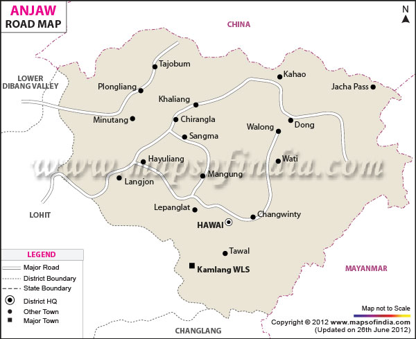
You can see Kibithu north of the better-known Walong in Anjaw district.
The place Kumki is not shown here, but would be east of Vijoyanagar (which, like Walong, has an Advanced Landing Ground which can handle medium transport aircraft such as the AN-32 and C-130J).
As Wikipedia has got it wrong, let us explore Walong and its surroundings in Anjaw district on Google Maps:
https://www.google.com/maps/@28.1383739,97.0662292,11z?hl=en
Anjaw is the easternmost district of India. Naturally its HQ at Hawai is the eastermost district HQ at 96.8027 E. The easternmost subdivision is Walong, whose HQ is at Walong (97.067 E).
Walong listed as a cantonment and town, at longitude 97.0167 E
Dong listed as the easternmost village in India, at longitude 97.0412 E
Kibithu listed as one of the easternmost towns in India and the easternmost roadhead in India, at longitude 97.0156 E which is west of Walong and Dong.
And the village closest to the Chinese border in this locality is Kaho, near Kibithu.
There is a post office at Walong (Pin code 792104) which covers these places. It would be the easternmost post office in India.
The easternmost bank branch is that of SBI at Hawai in Anjaw district, (96.8027 E). While there are several bank branches in Changlang district, none are so far east.
Also note the tri-junction of India, China and Myanmar about 20 Km east of the Walong-Kibithu route, apparently without any inhabited place in between.
However, the curiously-named village of Dong would be the easternmost civilian inhabited place in India-even though it consists of 3 huts (and a population of 15 in 4 households). The children go to school in Walong.
In spite of its remoteness it does attract a small number of tourists. Walong is reachable by road via Tezu (which was once served by Vayudoot flights, and now may have Pawan Hans helicopter services run by the state government). Otherwise one can start from Mohanbari airport or Tinsukia railway station.
As a formality, we also visit the “undisputed” easternmost point in the vicinity of Vijoyanagar in Changlang district:
https://www.google.com/maps/@27.1925253,96.9753302,11z?hl=en
There does not seem to be any civilian inhabited place between Vijoyanagar and the Myanmar border. This has a longitude of 96.9939 E which is west of Walong and its neighbours. Changlang district has numerous places of tourist interest (including the Miao sactuary) which can be reached from Mohanbari airport or Tinsukia railway station.
However, life in Vijoyanagar is hard, as you can read here: https://yobindreams.wordpress.com/2013/06/27/non-existence-of-road-inflicts-miseries-a-story-of-vijaynagar-changlang-district/
That is based on an article written in 2009. Perhaps things have improved since then.
Fortunately the western and southern extreme points of India are not so remote, as we will see later.
More detailed maps of Anjaw and Changlang districts: