Today is MH 370 Day

We generally know March 8 as International Women’s Day. In years to come it may well become known as MH 370 Day. On this day in 2014, a Malaysia Airlines Boeing 777 with 239 aboard disappeared soon after it took off from Kuala Lumpur for Beijing on a flight listed as MH 370. It was a totally routine flight until the transponder was switched off at 17.19 UTC/GMT (or 22.49 IST). Three years later, the final location and fate of the plane and its occupants remain a mystery.

Whatever is generally known is given here:

https://en.wikipedia.org/wiki/Malaysia_Airlines_Flight_370

There are numerous forums/mailing lists still devoted to this incident. One of the better ones is

http://jeffwise.net/

You may also be interested in this bit I wrote about the Indian angle. It has some general information about the Andaman and Nicobar Islands:

https://abn397.wordpress.com/2015/03/07/mh-370-the-indian-angle/


The southernmost points of India

The standard answer to this one is Kanyakumari (also called Cape Comorin), which is indeed the southernmost point on the Indian mainland. Unlike the other extreme points, this is well populated and linked to other parts of the country. It is officially at 8.078 N, 77.541 E. Here is the main tourist area:

https://www.google.co.in/maps/place/Kanyakumari,+Tamil+Nadu+629702/@8.0829211,77.5446251,15z/data=!4m2!3m1!1s0x3b04ed3d2a087861:0x1e790e896aeffaa0

The southernmost point on the mainland would probably be the place marked “Hidden twin beach”.

The railway station seen on this map has trains to all corners of India, including Katra in Kashmir and Dibrugarh in Assam.

Kanyakumari was earlier in Travancore state, then Travancore-Cochin state and was finally transferred to Madras state (now Tamil Nadu) when linguistic states were formed.

But the true southernmost point of India lies in the Andaman and Nicobar islands (not the islands of Lakshwadeep as their southernmost point is around the same latitude as Thiruvananthapuram). To be precise, the southernmost point is a settlement called Indira Point on the southern tip of Great Nicobar island.

https://en.wikipedia.org/wiki/Indira_Point

This article mentions that there are 4 households in this settlement with a total population of 27 (all males). It also mentions how many are literate and how many are from reserved categories. Presumably most (if not all) of them are connected with the lighthouse.

Here is a video of the area shortly after the tsunami of 2004:  https://www.youtube.com/watch?v=XRA4sCNTN4E

Note how the lighthouse has sunk into the water. It is functioning again now.

There appears to be a helipad nearby. Also note the numerous small buildings near the lighthouse.

While tourism is being encouraged in some parts of the Andamans, even Indian citizens cannot visit Nicobar district without permission from the union territory’s government. There are ships and helicopter services to nearby Campbell Bay, which has India’s southernmost airport and naval base. This could be described as the southernmost village in India (population around 5700). Due to the military presence, it has amentities such as banks and a Kendriya Vidyalaya (school run by the federal government).

It is not often appreciated that these islands, particularly in the Nicobar group, are considerably closer to other countries than to India. This map should give an idea:

https://www.google.co.in/maps/place/Indira+Point,+Andaman+and+Nicobar+Islands+744302/@12.2829531,91.787832,6z/data=!4m2!3m1!1s0x30693681c618213f:0xf4a05f017d87b04a

The straight-line distances from Indira Point to various places in India:

Port Blair-554 Km

Chennai-1646 Km

Kolkata-1855  Km

And to some places in other countries:

Banda Aceh, Indonesia-215 Km

Phuket, Thailand-515 Km

Colombo-1538 Km

Yangon-1153 Km

Think about it. Indira Point is closer to Indonesia and Thailand than to Port Blair. And Yangon and Colombo are closer to it than any mainland Indian city.

The Andaman and Nicobar islands were occupied by Japanese forces during WW2, and were nominally governed by the Indian National Army.

https://en.wikipedia.org/wiki/Andaman_and_Nicobar_Islands#World_War_II

Regarding the research stations in Antarctica starting with Dakshin Gangotri, it appears that India does not have any territorial claims over Antarctica while some other countries do.

https://en.wikipedia.org/wiki/Indian_Antarctic_Program


MH 370: The saga STILL continues

I have written on this topic before. Here is a summary of what was known in December 2014:

https://abn397.wordpress.com/2014/12/27/mh-370-the-saga-continues

and a later comment on the Indian angle:

https://abn397.wordpress.com/2015/03/07/mh-370-the-indian-angle/

As mentioned earlier, one forum which attracts a fair number of well-informed comments is:

http://jeffwise.net/

Sometimes a single article attracts over 1200 comments, which are worth reading if you want to know about this deepest of mysteries.

Basically the old idea that the crash’s location was determined by the BFO transmissions is being given less credence now-so if the plane did not go to the southern Indian Ocean, where else could it have gone? This aspect is studied by Victor Iannello here:

http://jeffwise.net/2015/04/29/guest-post-northern-routes-for-mh370-ending-at-airports/#more-3915

Anyone a bit familiar with Indian aviation would see something wrong in his scenario. Look at the map and then see my comment (among the first few).

MH 370-the Indian angle

As the anniversary of the disappearance of MH 370 draws around, we look back at some news reports from last March considering what India may have been able to do at that time and why they did not do anything.

While the transponder on MH 370 ceased to function while approaching the Vietnamese coast, it was still trackable by primary radar until it went out of range. This is the last definitive information we have about its path:

MH370_flight_path_with_English_labels.png

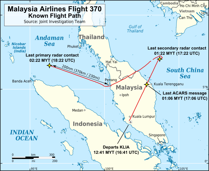
Note that at the last point it is heading towards the Nicobar islands.

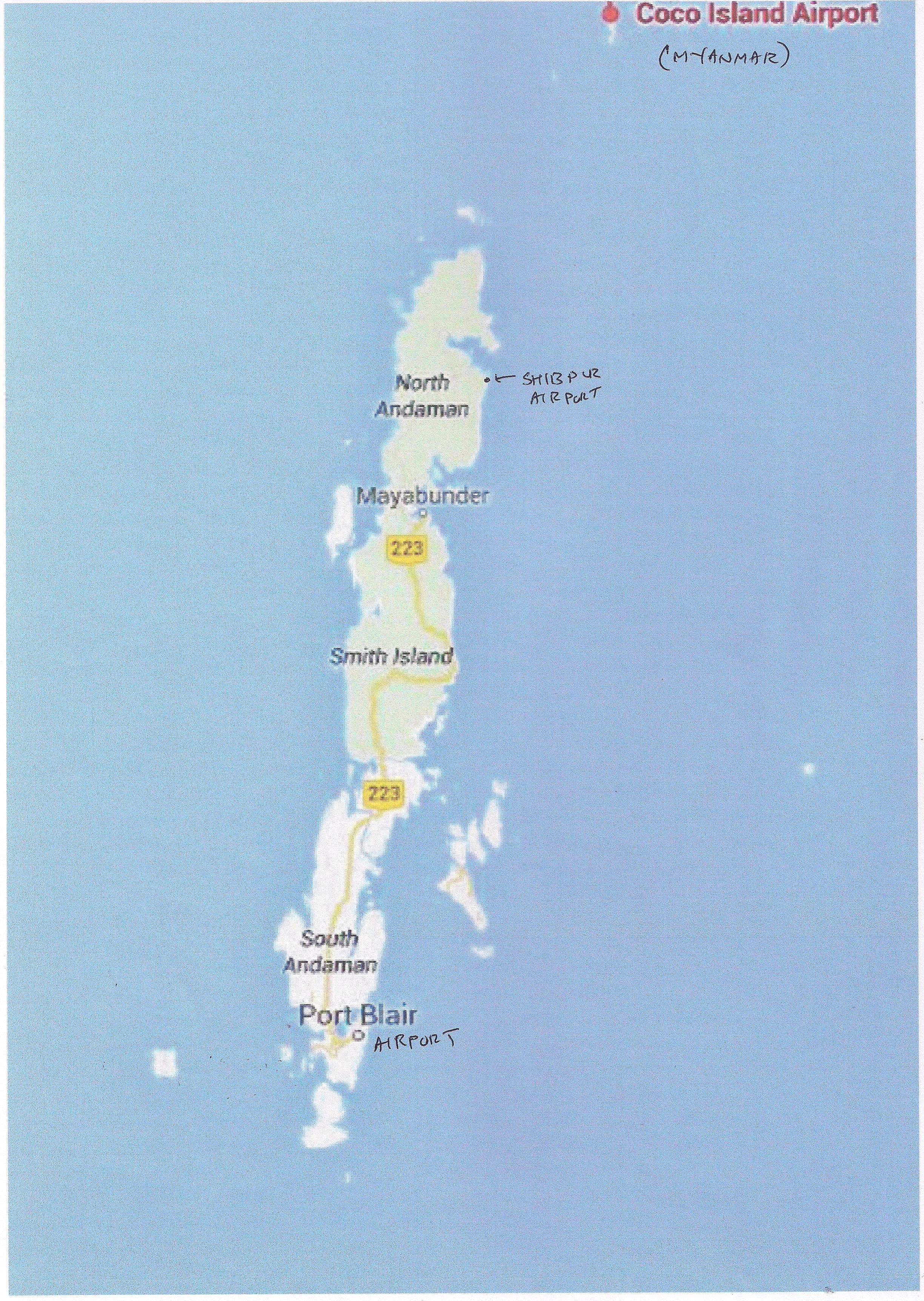
We first look at this report discussing possible landing sites in the Andamans and the nearby Coco islands (which are Myanmarese territory). This was written before the Inmarsat pings and the Southern Indian Ocean trajectory became common knowledge.

http://www.ibtimes.co.in/missing-malaysia-airlines-mh370-deliberately-diverted-towards-andaman-and-nicobar-islands-list-of-unused-airports-where-the-plane-possibly-landed-photos-543391

Of course, landing at the Indian airports at Campbell Bay, Car Nicobar, Port Blair and Shibpur could not have happened without the knowledge (or connivance) of the Indian armed forces. And the path to the Coco Islands should have been detected by Port Blair’s radar if it was working.

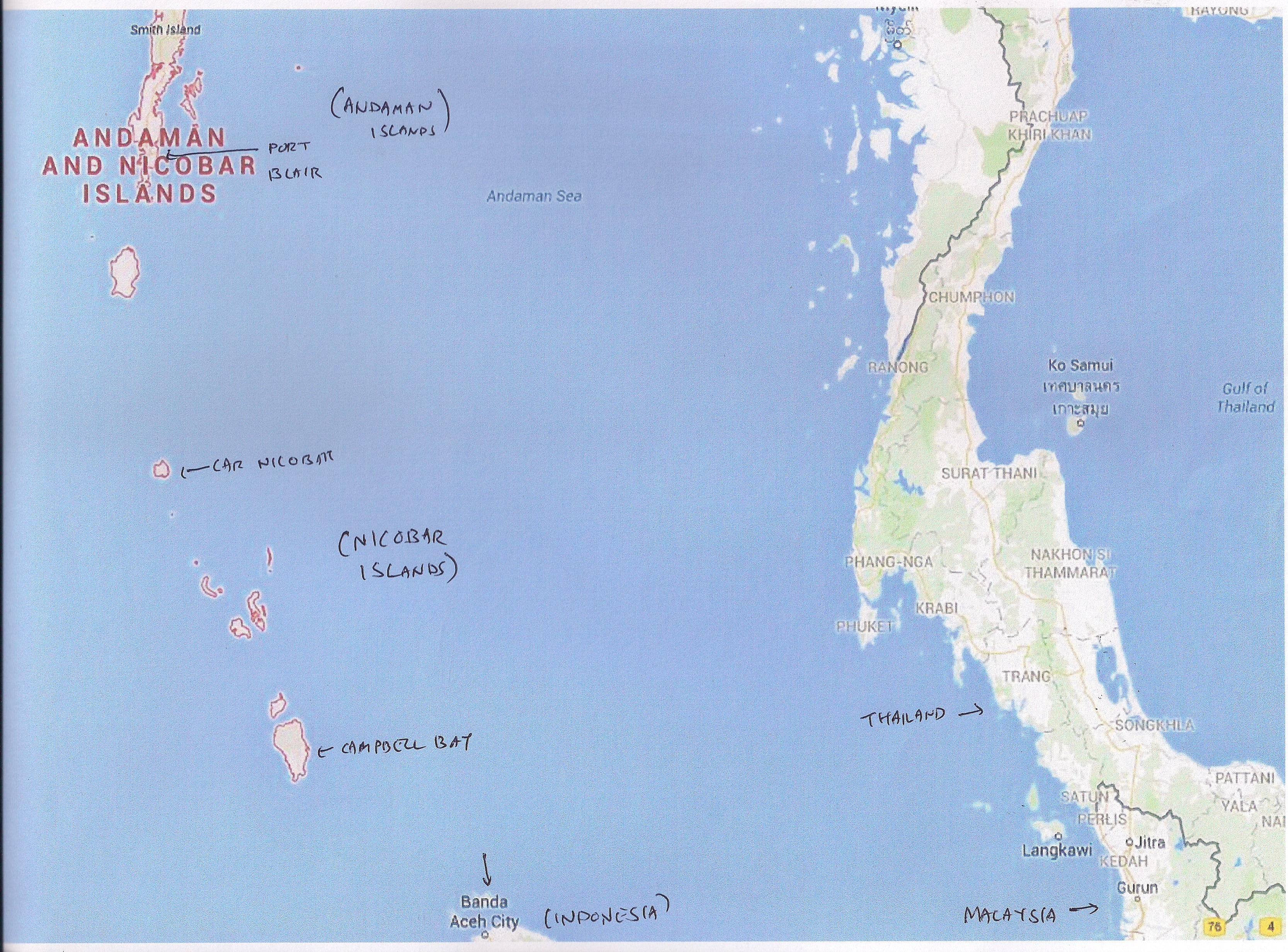
As this is the most remote part of India, a few maps may be helpful for orientation:Andamans-A 001

Note that the Andamans and the Nicobars are distinct island groups. They are grouped together as a single territory called “The Andaman and Nicobar Islands”, as in the map above.

Most of the population is in the Andamans, and the Nicobars have little population outside the Indian military bases. The forests of both island groups are largely inhabited by tribes who have little contact with the outside world. (You may recall the poison dart man from “The Sign of Four”).Very few Indian civilians (other than those employed by the government) are allowed to travel to the Nicobars.

Another point of interest is that the islands are considerably closer to Myanmar and Indonesia than they are to India. In turboprop days the Indian Airlines Viscount flights from Calcutta to Port Blair used to refuel at Rangoon. Direct flights started only with the 737s.

The islands had been occupied by the Japanese for a long period during WW2.

A closer look at the Andamans (and the Coco Islands):

Andamans-B 001

Here you see the main town of Port Blair, its airport (which is run by the military, who allow civilian flights for part of the day), the little-used airstrip at Shibpur and the Coco islands.

And finally the Nicobars:

Andamans-C 001

Here we see Car Nicobar with its 8900-ft airfield which was wrecked in the 2004 tsunami and promptly rebuilt, and the smaller base at Campbell Bay which handles smaller aircraft and probably has little or no radar. Car Nicobar does handle 737s and A320s on military charters, besides Il-76s and the smaller military transports such as AN-32s.

Note the proximity to Banda Aceh which would have been circumnavigated by MH 370 as many believe.

Now a couple of articles by an Indian aviation expert. This newspaper and the writer are generally considered to be reliable. Of course, these articles are based on what was known at the time of writing.

From the Hindu of 18/03/2014:

http://www.thehindu.com/news/national/disturbing-scenarios-on-mh370/article5797358.ece

and from the same paper of 26/03/2014:

http://www.thehindu.com/opinion/op-ed/the-possibility-of-pilot-suicide/article5831677.ece

These two articles reflect what was known at that time. I am not sure whether the writer’s comments about the state of affairs at the radar facilities at Car Nicobar and Port Blair are fully reliable. But if the Car Nicobar radar was functioning, it would certainly have caught some part of the track of MH 370 before if it disappeared towards the South Pole (or to the Maldives or Diego Garcia if you believe those theories).

However, even if you stick to the northern path to Baikonur or nearby, it would be difficult for it to get through the radars of Kolkata international airport and several large air force bases in eastern India where the radar would be better monitored than in the sleepy outposts in the islands.

Footnote: A total of 239 persons were aboard the missing aircraft, being 12 crew and 227 passengers. 5 passengers were listed as Indian citizens. There may have been a few crew members and passengers from Malaysia with Indian-sounding names.