Oddities in Indian history-Chandernagore/Chandan Nagar

The history of the French territories in India gets little or no mention in school history nowadays. Most of us vaguely know about the Union Territory of Puducherry, Karaikal, Yanam and Mahe whose constituents have tenuously clung on to their “privileged” status despite several determined attempts to incorporate them into the adjoining states.

We will return to the Union Territories and their oddities later. For a quick overview see this:

http://en.wikipedia.org/wiki/French_India

Chandernagore (now Chandan Nagar) was an integral part of French India along with the southern territories mentioned above.It was a tiny pocket of 19 sq km surrounded by British India, though it did abut the Hooghly. The main railway line from Howrah to Barddhaman (Burdwan) did have a station named Chandernagore though it seems to have been just outside French territory. It still survives as Chandan Nagar and is served by many EMU locals and a handful of long-distance trains.

You may hear that the railway line runs outside the former territory because the British railway engineers did not want their line to pass through foreign territory. My friend Souroshankha Maji, who has studied the history of this area in detail, feels that this “diversion” was more because of the desire to create a straighter and more convenient alignment rather than to avoid the territory.

The station was renamed (or rather restored to its original name) Chandan Nagar after the 1940s.

The old station:

Chandernagore-gare

The present station:

Chandan Nagar

The adjacent station of Chinsura, once part of Dutch India, was similarly renamed Chuchura.

However, there were some other cases where alignments avoided certain territories because of some problems associated with their governments. A good example is Rampur in what is now Uttar Pradesh, where the rulers initially did not permit the main Lucknow-Amritsar line to pass through their territory. So the trains ran through another route via Chandausi which was built in the early 1870s. By the 1890s the rulers of Rampur relented and the line now runs through the town. It is even a junction now.

Once the British left in 1947, the new Government of India started making polite noises to the governments of France and Portugal stating that it would be a good idea to give independence to their colonies in India. Portugal, in line with its semi-fascist government’s policy,  told India to get lost and continued to do so until they lost some of their colonies in 1954 and all of them by 1961.

The French were more willing to listen.They probably felt that the Bengalis of Chandernagore were more likely to create trouble than their compatriots in Southern India so Chandernagore was the first to be given independence in 1948. This followed a referendum in which 97% of the population voted for independence.

The handover was in May 1950. In due course Chandan Nagar became a subdivision of Hooghly district and thus an integral part of West Bengal. It does have many traces of its French heritage and there is some attempt by West Bengal’s government  to market it as a tourist spot. It is, after all, within easy reach of Kolkata by road and rail.

The population can be said to be a bit unlucky, since the more obscure places like Karaikal, Yanam, Mahe, Dadra & Nagar Haveli, Daman and Diu continue to enjoy their UT status. Among other things, this allowed a complete backwater like Silvassa (DNH) to become an industrial hub of sorts. Daman and Diu (particularly the latter) are relatively unspoiled and probably derive much of their revenue from alcohol-starved Gujaratis on weekends. Some tourist guidebooks and websites specifically warn unwary visitors against this.

For more details see

http://en.wikipedia.org/wiki/Chandannagar

Subsequent blogposts on this topic will cover Oman’s outpost in India, and answer the question why DNH is an Union Territory in the first place, and will reveal the hidden enclave of Diu in Gujarat which most atlases and even Google Maps do not know about.
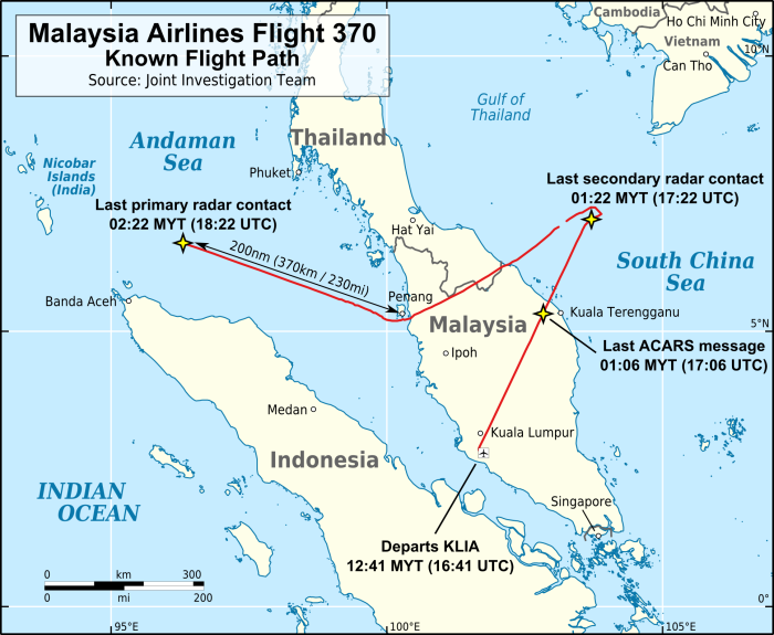
MH 370-the Indian angle

As the anniversary of the disappearance of MH 370 draws around, we look back at some news reports from last March considering what India may have been able to do at that time and why they did not do anything.

While the transponder on MH 370 ceased to function while approaching the Vietnamese coast, it was still trackable by primary radar until it went out of range. This is the last definitive information we have about its path:

MH370_flight_path_with_English_labels.png

Note that at the last point it is heading towards the Nicobar islands.

We first look at this report discussing possible landing sites in the Andamans and the nearby Coco islands (which are Myanmarese territory). This was written before the Inmarsat pings and the Southern Indian Ocean trajectory became common knowledge.

http://www.ibtimes.co.in/missing-malaysia-airlines-mh370-deliberately-diverted-towards-andaman-and-nicobar-islands-list-of-unused-airports-where-the-plane-possibly-landed-photos-543391

Of course, landing at the Indian airports at Campbell Bay, Car Nicobar, Port Blair and Shibpur could not have happened without the knowledge (or connivance) of the Indian armed forces. And the path to the Coco Islands should have been detected by Port Blair’s radar if it was working.

As this is the most remote part of India, a few maps may be helpful for orientation:Andamans-A 001

Note that the Andamans and the Nicobars are distinct island groups. They are grouped together as a single territory called “The Andaman and Nicobar Islands”, as in the map above.

Most of the population is in the Andamans, and the Nicobars have little population outside the Indian military bases. The forests of both island groups are largely inhabited by tribes who have little contact with the outside world. (You may recall the poison dart man from “The Sign of Four”).Very few Indian civilians (other than those employed by the government) are allowed to travel to the Nicobars.

Another point of interest is that the islands are considerably closer to Myanmar and Indonesia than they are to India. In turboprop days the Indian Airlines Viscount flights from Calcutta to Port Blair used to refuel at Rangoon. Direct flights started only with the 737s.

The islands had been occupied by the Japanese for a long period during WW2.

A closer look at the Andamans (and the Coco Islands):

Andamans-B 001

Here you see the main town of Port Blair, its airport (which is run by the military, who allow civilian flights for part of the day), the little-used airstrip at Shibpur and the Coco islands.

And finally the Nicobars:

Andamans-C 001

Here we see Car Nicobar with its 8900-ft airfield which was wrecked in the 2004 tsunami and promptly rebuilt, and the smaller base at Campbell Bay which handles smaller aircraft and probably has little or no radar. Car Nicobar does handle 737s and A320s on military charters, besides Il-76s and the smaller military transports such as AN-32s.

Note the proximity to Banda Aceh which would have been circumnavigated by MH 370 as many believe.

Now a couple of articles by an Indian aviation expert. This newspaper and the writer are generally considered to be reliable. Of course, these articles are based on what was known at the time of writing.

From the Hindu of 18/03/2014:

http://www.thehindu.com/news/national/disturbing-scenarios-on-mh370/article5797358.ece

and from the same paper of 26/03/2014:

http://www.thehindu.com/opinion/op-ed/the-possibility-of-pilot-suicide/article5831677.ece

These two articles reflect what was known at that time. I am not sure whether the writer’s comments about the state of affairs at the radar facilities at Car Nicobar and Port Blair are fully reliable. But if the Car Nicobar radar was functioning, it would certainly have caught some part of the track of MH 370 before if it disappeared towards the South Pole (or to the Maldives or Diego Garcia if you believe those theories).

However, even if you stick to the northern path to Baikonur or nearby, it would be difficult for it to get through the radars of Kolkata international airport and several large air force bases in eastern India where the radar would be better monitored than in the sleepy outposts in the islands.

Footnote: A total of 239 persons were aboard the missing aircraft, being 12 crew and 227 passengers. 5 passengers were listed as Indian citizens. There may have been a few crew members and passengers from Malaysia with Indian-sounding names.