There are some countries like Britain whose extreme points are well documented. The little towns of Land’s End and John O’Groats are well-known tourist spots.
In many countries one or more borders and extreme points are in remote areas-particularly so in India’s northern and eastern borders. There is a difference between:
- What the Indian government says its borders are
- What area is actually controlled by the Indian government
- What area is disputed by other countries (though this is really of no concern to the Indian public, one has to see maps published from other countries which show a large area as disputed).
One can also look up the definitions of “de jure” and “de facto” if one wants to be further confused.
Anyway, this Wikipedia article claims to mention all the extreme points of India. For today we deal with the northernmost points, and we will return to the other points later.
https://en.wikipedia.org/wiki/List_of_extreme_points_of_India
We start with a typical map of Jammu and Kashmir from a school atlas:
If one was to take this seriously, the international borders shown here are the true borders of the India since Independence.

A point of interest is the thin sliver of Afghanistan (known as the Wakhan corridor) bordering India’s territory. Crossing this you enter Tajikstan, formerly part of the USSR.
But what is actually controlled by India? This map from Wikipedia sums it up:

Note the green area which has been controlled by Pakistan since shortly after independence, although minor changes have occurred in the 1965 and 1971 wars.
Then there is the Aksai Chin (in beige, like the rest of China and Tibet) which was taken over by China some time in the mid-1950s, without the Indian government or armed forces knowing about it. Also note that a portion of south-eastern Ladakh is held by India and is marked as disputed.
The Siachen glacier (in white) was not permanently occupied by any government until the Indian armed forces occupied positions there in 1984.
Then there is the Shaksgam valley which is supposed to be in India, and was occupied by Pakistan and later transferred to China.
So you can see that the northern-most point actually occupied by India’s forces would be somewhere near the northern end of Siachen, on the border with Xinjiang province of China.
Now we look back to the Wikpedia article referenced earlier: If you click on the co-ordinates you will end up with a map showing the location. But it may take less time if you first open Google maps or Wikimapia etc and enter the coordinates yourself.
The borders will be shown differently if you are using google.co.in or, say, google.com. (Update: This was true in 2016, but not now as the borders in all Google versions shows the same border as in Google.co.in).
The first point shows what may be the northernmost Indian military post at Indira Col in the Siachen, with latitude approximately 35.6745 N.
The second shows a place some distance along the Karakoram highway near Tashkargan, the first town in Xinjiang.
And the third shows the northernmost point of Himachal Pradesh (since the whole of J & K is disputed 🙂 )
This is all rather messy, so you may prefer the map referenced here:

which shows the location of Indira Col with reference to the Line of Control.
This article explains the significance of NJ 9842 and the line heading northeast from it:
https://en.wikipedia.org/wiki/Siachen_Glacier
There are a few helipads in the glacier area. One of them, at Point Sonam, has been listed as the world’s highest helipad at 21,000 ft. It is referenced here: https://en.wikipedia.org/wiki/Helipad
Apart from the location above, there is a built-up area at Daulat Beg Oldi (DBO) airstrip:
https://en.wikipedia.org/wiki/Daulat_Beg_Oldi
which is at 35.390 N . Note the comment:
“Other than Siachen Glacier military bases, it is India’s northernmost built-up area.” There is a nearby small town of Murgo, (35.0411 N) which is not yet connected by motorable road to Leh although some roads exist around DBO.
And DBO is listed as the world’s highest airstrip at 16,600 ft. It was first operated with Packet aircraft in 1962, and now handles AN-32s and C-130Js. References are given in the Wikipedia article.
The northernmost town which can be visited by the Indian public is now Warshi:
http://vargiskhan.com/log/warshi-village-nubra-valley-opened-travelers/nubra-valley-opened-till-warshi-village/
Also see this map for the roads here:
http://vargiskhan.com/log/warshi-village-nubra-valley-opened-travelers/leh-to-nubra-valley-map-with-distances-2/
Warshi’s latitude is 35.0629 N, while the previous northernmost accessible place was Turtuk with 34.8474 N. Turtuk was under Pakistan’s control until 1971.
Fortunately the extreme points in the west, east and south are not so confusing. We visit them next.
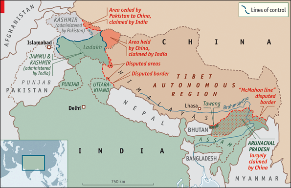
Footnote: here is another map of disputed territories, which seems to have appeared in “The Economist” at some point. We will meet it again when we come to the eastern extreme points.
You may also like this one about disputed territory on the Uttarakhand border:
https://abn397.wordpress.com/2016/07/29/where-is-barahoti/
Tail piece: Indian journalists routinely mis-spell the McMahon line as the MacMohan line, thinking of the second-rung villain of Bollywood:
http://indiatoday.intoday.in/gallery/actor-mac-mohans-life-in-pics/1/3163.html
A travelogue on Turtuk, which was opened to tourists some years ago:
http://www.bbc.com/travel/story/20190730-the-village-that-lost-its-country


