The Assam Bengal Railway in 1929

I happened to run into a British expert in railway history who had material from all over the world. One of the things he had was an Assam Bengal Railway timetable of 1929. He was kind enough to send me scans of a few pages from it. These are mainly from Sylhet and Cachar districts of the past.

ABR-1929 coverABR-1929 mapAssam Bengal TT p 014Assam Bengal TT p 015Assam Bengal TT p 016Assam Bengal TT p 023Assam Bengal TT p 026

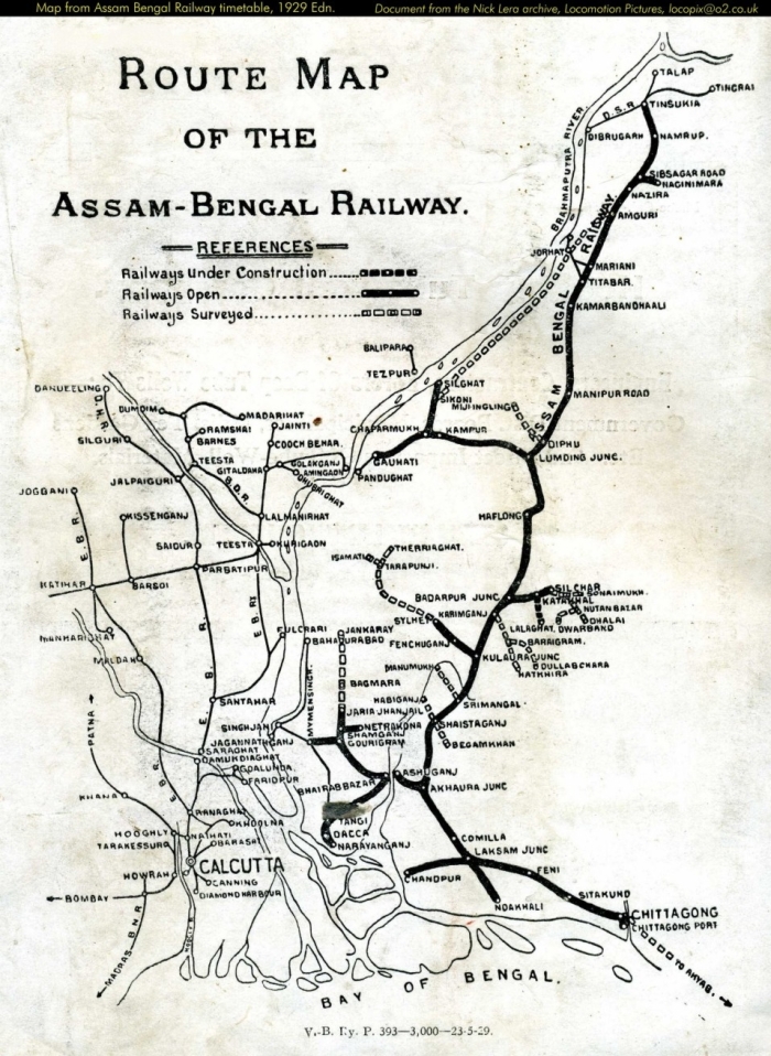
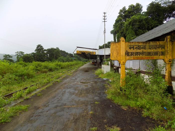
Those familiar with the NFR would recognize the cover picture of a point on the Lumding-Badarpur section.

The Assam Bengal Railway ceased to exist in 1942 when it was combined with the Eastern Bengal Railway to form the Bengal & Assam Railway, which effectively covered all railways to the east of the Hooghly. This was primarily to facilitate efficient running of the war against Japan, and the US armed forces took control of the main routes into and in Assam.

This new creation lasted only a few years. Partition caused the B & A R to be broken into three parts. The BG lines left in West Bengal essentially became the Sealdah division of the EIR, which was then broken up into the ER and NR. What was left (both BG and MG besides a bit of NG) in East Pakistan was initially called the Eastern Bengal Railway until 1961, then the Pakistan Eastern Railway and finally Bangladesh Railways.

The MG lines in northern West Bengal, a bit of Bihar and everything to the east were combined with a few smaller systems (such as the NG Darjeeling Himalayan Railway and the company-owned lines around Tinsukia) became first the Assam Railway, then part of the North Eastern Railway and finally the Northeast Frontier Railway in 1958.

Some points of interest:

No express or mail trains served Chittagong and Sylhet. They were not directly connected to Dacca and other parts of present-day Bangladesh as there was no bridge over the Meghna at Ashuganj/Bhairab Bazar (though there was a ferry). The bridge was opened only in 1937. It was named the King George VI bridge. Had it opened a year earlier, it may have been one of the few things to be named after King Edward VIII.

There was, however, the Surma Mail which you can see running from Chandpur to Silchar via Laksam, Akhaura and Karimganj. Possibly it had slip coaches for Chittagong and Sylhet, though these would be mentioned elsewhere in the timetable. It would have started from Sealdah and passengers would have to travel in the ferry from Goalundo Ghat to Chandpur. Other ferries linked Goalundo Ghat to Narayanganj (for Dacca).

Note that extracts from various old timetables can be seen here:

http://www.irfca.org/gallery/Heritage/timetables/ 

Most of these are small fragments, as it is a painful process to scan large numbers of pages from the fragile originals. Even so, there are complete timetables of the North Western Railway and Jodhpur Railway from the 1944 Bradshaw, which cover the entire area of Pakistan and parts of Rajasthan and UP, besides most of Haryana and Punjab.

There is a copy of the June 1944 Bradshaw which someone got hold of, which has been repeatedly copied and circulated to dozens of railfans connected with the IRFCA group. Someone seems to have got hold of the Bradshaws of the 1930s and has put up a few pages pertaining to present Tamil Nadu and Kerala.

There is also a full timetable of the BB & CIR from 1937 (roughly corresponding to the pre-2002 WR).

In case you are wondering, foreign websites (mainly abebooks.com, also ebay.com, Amazon.com and Amazon.co.uk) occasionally stock old Indian zonal timetables and Bradshaws from small independent booksellers (mainly in the UK). But any Bradshaw or all-India TT before the 1980s may cost a few hundred US dollars. Old zonal timetables are rarer but not so expensive-for instance, a few years ago one NWR timetable of 1930 was available for about 35 USD including shipping to India.

The southernmost railways in India

There are some questions which can be answered easily by a layman. But if you ask a more knowledgeable person you may get a more complicated answer.

Q: Which is the southernmost point of railways in India?

A: Kanniyakumari station is the simple answer:

Kanniyakumari

A plaque at this station says that it was inaugurated by the then PM Morarji Desai on 15 April 1979. Its latitude is 8.0864 N from Google Maps.

Its code is CAPE. But the station never had this name. This is because the place was also known as Cape Comorin earlier on. To be more precise, the southernmost point of the Indian mainland is still called Cape Comorin.

Footnote: For a long time before the mid-50s, Kanniyakumari was part of Travancore state before the reorganization of states placed it in the then Madras state as a majority of people in the taluk were Tamil-speaking. But as Travancore state was predominantly Malayalam-speaking, some station signboards had Malayalam inscriptions until a few years ago. Maybe they still exist.

Q: Before that, which was the southernmost point?

A: If one looks at earlier timetables, the southernmost stations as of 1975 were Trivandrum Central (TVC) and Tiruchendur (TCN). It was difficult to make out which was southernmost from ordinary atlases. With the aid of Google Maps, we see that TVC is at 8.4870 N and Tiruchendur is at 8.4986 N. So we see that TVC was the southernmost station until the opening of the lines from TVC and Tirunelveli to Kanniyakumari.

However, if you take the distance between the parallels of latitude then TVC was a little over 1.2 km south of TCN. A narrow win indeed!

Trivandrum

Though the city was traditionally known as Thiruvananthapuram, it was not until 2007 that this and many other stations in Kerala were renamed to fit the Malayalam versions.

A recent picture of the former runner-up:

Tiruchendur

You can see an overview here: https://www.google.co.in/maps/place/Nagercoil,+Tamil+Nadu/@8.6366475,77.5674675,10z/data=!4m5!3m4!1s0x3b04f0dfc0ddc7b7:0x809a9e32a95d3ed1!8m2!3d8.1832857!4d77.4118996

By enlarging this map you can see the two BG lines from TVC and Tirunelveli meeting at Nagercoil Jn, from where a short branch goes to Kanniyakumari.

In 1975, TVC and TCN were both MG. By 1976 the BG line from Ernakulam was extended via Quilon to TVC, and continued to Kanniyakumari after that. TCN got broad gauge much later in the 2000s.

Q: Did any other railway exist in the deep south before that?

A: Yes, the privately owned KPN Light railway existed (with its main station at Tiruchendur) until it was closed (due to economic reasons, perhaps connected to World War 2) in about 1940. It was 2’0″ narrow gauge. It was duly mentioned in Bradshaws before then, as you can see here:

Kulasekarapatnam line TT

This was owned by the Madras-based Parry’s group of industries to facilitate their activities in that area-in particular, a sugar factory at Kulashekarapatnam. Passenger services were probably more of an afterthought.

If one looks at the map carefully one can see that the southernmost station was Tissianvillai which was indeed the southernmost station in India (at the time it existed), as its latitude was 8.3353 N, somewhat south of TVC. The route of this tiny railway system can be seen here.

https://www.google.co.in/maps/place/Thisayanvilai,+Tamil+Nadu/@8.4062791,77.9075378,12z/data=!4m13!1m7!3m6!1s0x3b04f0dfc0ddc7b7:0x809a9e32a95d3ed1!2sNagercoil,+Tamil+Nadu!3b1!8m2!3d8.1832857!4d77.4118996!3m4!1s0x3b047e50930e95e5:0x1d70ec9eff576a24!8m2!3d8.3349894!4d77.8652573

Whatever little is known about this system is here: https://wiki.fibis.org/w/Kulasekharapatnam_Tissainvillai_Light_Railway

The Tiruchendur station on this line was probably at a different location from the “real” station on metre gauge.

A few years ago a determined rail-fan friend of mine tried to find some existing physical remnants of the track but was unsuccessful. As many years had passed most of the local people did not know much about the track, and no former employee could be found in the vicinity. But there were some who vaguely remembered their grandfathers working on the line.

Q: OK, so that is true of the mainland (though this last line was not really a part of the Indian Railways). What about the island territories?

A: A good question, but you won’t catch me here. There is no record of any industrial railway in Lakshwadeep, but in any case the southernmost point of this territory is on Minicoy which is around the same latitude as Trivandrum.

The Andaman and Nicobar Islands look more promising. Indeed, some industrial railways have existed in the vicinity of Port Blair, serving the numerous sawmills there. But this has around the same latitude as Puducheri.

If there were any such lines in the Nicobar islands, they would be the southernmost railways ever to have existed in India. But there is no record of these, as the Nicobar region remains largely undeveloped even today.

Thanks to Bharath Moro for his account of his search for remnants of the KPN line.

Where trains do not run any more (2019)

Copyrights of the pictures rest with the respective photographers.

Some stations to which no train runs now.

First, one in Gujarat where the railway line does not exist now:

Ghanta

The picture was taken in around 1980. The station was on the long-closed NG line from Champaner Road to Pani Mines, near Vadodara.

There are many narrow gauge lines in Gujarat which have closed over the last few decades. Those which survived until the 2010s will ultimately be converted to broad gauge.

Another of these ill-fated NG lines was the Samlaya-Dabhoi section which was affected by floods some years ago . Here are some remnants:

Samlaya NG

Samlaya’s NG station. The BG station can be seen in the background.

Here is one of the wayside stations:

Vagodiya (NG)

In Tamil Nadu, there are numerous abandoned branch lines which closed between the 1960s and 1980s. Some branches, such as the one to Mannargudi, have been rebuilt in recent years. The branch to Mettur Dam was reopened for passenger traffic after a long gap. And Karaikal has been connected through a new branch.

Perhaps the most well-known abandoned terminus is Dhanushkodi. This is all that you will see now:

Dhanushkodi

The cyclone of December 1964 resulted in the closure of the Pamban-Dhanushkodi section, which was listed as the “main line” in timetables of that period. Damage to the line was extensive enough to result in it being abandoned and the branch to Rameswaram now became the main line with ferries to Talaimannar in Sri Lanka.

The disturbances in Sri Lanka from 1983 put an end to the ferry services. Though the civil war is now over and the connecting lines in Sri Lanka are functioning again, it is unlikely that the ferries will run in the foreseeable future. But Rameswaram, unlike Dhanushkodi, has enough traffic to justify train services to all parts of India.

This was once the easternmost point of IR, though the extension from Ledo was built only in the late 1950s. It was closed after the BG was extended to Ledo, and it was not felt worthwhile to convert the remaining line to Ledo to Lekhapani.

Lekhapani_station

However, one can see signs of economic activity here.

This was once the terminus at Ernakulam, once metre gauge and then broad gauge. It lost its importance in around 1940 when it was bypassed in a new alignment going to Ernakulam Town, Ernakulam Jn and Cochin Harbour Terminus. In its last years it was used only by departmental goods trains, and probably the last of them ran in 2001.

Ernakulam Goods

And there are these recently orphaned stations on the Lumding-Silchar section: (Bagetar is the one on the top left).

Here is the station at Lower Haflong after it was abandoned:

Lower Haflong closed

The abandoned alignment also includes the 1.9 km-long Longtarai tunnel between Lower Haflong and Ditokcherra.

Elsewhere in Assam, here is a current picture of Tezpur station. It is not likely to see trains again as there is insufficient space for broad gauge. Trains now terminate at the BG station at Dekargaon a few km to the north.

tezpur

In North Bengal, we have this former junction very close to the Bangladesh border:

Gitaldaha (abandoned)

It lost its importance after Partition as through trains ceased to run across the border. A newer station was built some distance away from the border and was called New Gitaldaha Jn. Limited trains continued to run to Gitaldaha according to the 1963 timetable, though it is not listed in timetables of the 1970s.

Our next stop is also in West Bengal, but on a more optimistic note:

Petrapole-2

This lies on the east of Bangaon, close to the border with Bangladesh. It saw some passenger traffic with the Sealdah/Khulna Barisal Express for some years up to the 1965 war. After that no traffic crossed the border for 25 years or more. Later goods trains from India started using the track-in 2008 many IR wagons could be seen at sidings on stations between Khulna and Jessore.

Finally a weekly express between Kolkata and Khulna started running in November 2017.

Then there were the famous narrow gauge lines of Martin Burn which ran useful commuter services on 2’0″ gauges into Howrah Maidan. They closed in around 1970. The Howrah-Amta line was converted to BG and electrified, though the Bargachia-Champadanga section remains closed.

The sister line from Howrah to Sheakhala  with the short branch from Chanditala to Janai remains as it was. However, some relics can still be seen:

Ghost stations such as the older Madgaon station exist or existed until recently. The old station lies on the Konkan line about a km north of the present station.

In Hyderabad, one can see traces of platforms at Husain Sagar which was listed in timetables at least till the 1970s. A little west of Lingampalli we can see the abandoned station of Telapur on the closed line to Patancheru. That line functioned only for a few years. The expected industrial boom in the then PM’s constituency of Medak never materialized.

And the former terminus at Patancheru is taken over by vegetation:

Patancheru

Update: Local services were resumed in mid-2019 up to Ramachandrapuram, one station before Patancheru.

Often, old stations are bypassed or lose importance in the course of construction of a new line or bridge. Many such stations in the present NF zone were rebuilt at new locations starting in the late 1940s, which accounts for the number of “New” prefixes in this area (Think of NJP and NBQ to begin with).

One such example in Bihar is Mungeri Lal’s hometown. Here are the old and new stations:

Travels in Chennai-ancient signboards

Our first stop is at Basin Bridge Jn (BBQ), where we have examples of ancient and modern signboards:

The food-minded may wish to hold a BBQ here, though you may have to first find a military hotel nearby.

Nearby there is Washermanpet, though the sign painters have some doubts about the name:

The official name is Washermanpet in the timetables. Also note the mis-spelling of the Hindi name. No picture of any new signboard seems to be available on the net.

Some years ago I have seen signs with Chromepet and Cromepet co-existing. Another well-known case is Hafizpet/Hafizpeta in the Hyderabad area.

An example of a run-down signboard in a totally run-down station:

Royapuram

Again, no picture of a new signboard is seen on the net. Tragic, as this station has the oldest surviving station building in India.  It was the first terminus in Madras where trains started running to Arcot (now Walajah Road) in 1856. The old terminuses in Mumbai and Kolkata had opened before this but the station buildings do not exist now. However, it now boasts a new electric loco shed.

Another station which is particularly obscure, as it does not seem to be mentioned in timetables even though it has a booking office which issues tickets. No picture of any new signboard can be located.

Pattabiram military siding


Chrome in Chromepet, Power in Powerpet

While travelling by train in the past, one would have often come across stations with strange-sounding names and wondered about the origin of the names. Now the internet has made it easy to answer these questions. To begin with, there is this suburban station between Chennai Beach and Tambaram:

Chrompet

It was listed in earlier maps and timetables as Chromepet. Now what is its connection with chrome?

The answer lies in: https://en.wikipedia.org/wiki/Chromepet#Etymology

The name came from the Chrome Leather Works which used to have a large factory there.

Note the mismatch between the English and Hindi inscriptions.

Also in Chennai is this station with this antique signboard:

Washermanpet

As you would guess, the place gets its name from the humble dhobi:

https://en.wikipedia.org/wiki/Washermanpet#History

Also note the misspelling of the Hindi inscription.

And this is its counterpart on the Singapore metro:

Dhoby Ghaut

The signboard reflects the run-down condition of Washermanpet and Royapuram, the latter being the oldest functioning station building on IR. It was the main terminus at Madras when trains started running in 1856. This signboard reflects the condition of the station which has somehow escaped demolition till now:

Royapuram

Finally, we visit this station next to Eluru in Andhra Pradesh:

Powerpet

Does it perhaps have something to do with the Marathas such as Sharad Pawar? Some of them spell their name as Powar*

However, Wikipedia has this to say:

https://en.wikipedia.org/wiki/Powerpet

in which the name is said to be in honour of Sir Power, a railway engineer. I could not find anything else about him. But it is wrong usage, as the correct form is Sir Ravindra Jadeja and not Sir Jadeja.

*The Powar clan, however does seem to be connected to this station near Itarsi in Madhya Pradesh:

Powarkheda

Long and short names of stations in India

Most readers will know the identity of the stations with the longest and shortest names in India.

Copyrights of all these pictures rest with their creators.

We take a look at some other long names, after the undisputed leader;

Venkat


Here are some others. They are from both North and South:

periyanaikanpalayamCheruvu MadhavaramOLYMPUS DIGITAL CAMERA


Tondalagopavaram

Giani Zail...Romana Albel SinghFatehabad C'watiganj

KolhapurNP Murail

This category involves initials, which would make a long name if spelt in full: NPA Shivrampally

BEML NagarVOC

This one is not that long, but may be the most difficult to pronounce by non locals:

Shrungavarapukota

As for the shortest names, there are two with two letters. One is well known, the other is not so well known though it is odd:

IbOd

The person seen in the “odd” sign is Vimlesh Chandra, a railway engineer who has collected a vast number of pictures of stations and other items of railway interest.

There are several other stations with 3-letter names:

AitAraBapBarDETOrrPen


And this one used to have 3 letters, which was changed to 4 letters for obvious reasons:

Baad

This listing is not intended to be comprehensive, but does include the longest name (Venkatanarasimharajuvaripeta) and the shortest names (Ib and Od).

Also see this for a global viewpoint:

http://www.railwaystationlists.co.uk/information/trivia.pdf


Zones and divisions of the Indian Railways

May be of interest to those who are into the study of the Indian Railways all over the country:

http://pib.nic.in/newsite/PrintRelease.aspx?relid=137331

Warning-not all the spellings are correct.

The above link is not working when I rechecked. An alternative is:

https://en.wikipedia.org/wiki/Zones_and_divisions_of_Indian_Railways

as well as:

https://erail.in/blog/zones-and-divisions-of-indian-railways

It is interesting if one wants to see how the newer zones were created. A rather obvious case is the North Western Railway which was formed from Jodhpur and Bikaner divisions of NR and Jaipur and Ajmer divisions of WR, thus creating a zone whose jurisdiction covers most of Rajasthan.

Similarly, the East Central Railway was formed from Danapur, Dhanbad and Mughalsarai divisions of ER and Samastipur and Sonpur divisions of NER, thus covering most of Bihar.

The North Central Railway has a rather mixed parentage. It includes the divisions of Allahabad (ex NR), Jhansi (ex CR) and Agra (a new division with bits and pieces of WR, CR and NR, perhaps even NER).

One particularly odd thing is the Waltair division. Waltair is a suburb of Visakhapatnam where the main railway station is located. Waltair was renamed to Visakhapatnam over two decades ago but the division name remains.

But there are counter-examples of this. On SR there used to be the Olavakkot division which became the Palghat division and finally the Palakkad division, in line with the changes of the name of the station.

There are plenty of other points of interest in this listing, particularly for those into the history of IR.

Important note: The proposed South Coast zone and its divisions are very unclear at the time of writing.


Revival of the Barisal Express

Much excitement has been caused among those connected with the Railways by the imminent start of the new cross-border train between Kolkata and Khulna.  Trial runs  were held a few days ago and many videos can be seen on Youtube showing the train running at various places along the line to Bangaon and beyond. Here is an example:

The earlier Maitree Express, now running between Kolkata and Dhaka Cantt, follows a route in which much of the route in Bangladesh did not exist before Partition. There had been trains with names like the Dacca Mail which started from Sealdah and terminated at Goalundo Ghat, from where the passengers embarked on a ferry trip of several hours to Narayanganj on the outskirts of Dacca (as it was then spelt). By 2001 the Bangabandhu Bridge had been completed along with a connecting line to Dhaka. This provided a route from the Gede-Darsana border to Dhaka without a ferry crossing. More about that in another post.

This new service between Kolkata and Khulna revives a pre-partition train called the Barisal Express between Sealdah and Khulna which was running since at least the 1930s. In fact it was running for some time after Partition and was listed in the ER timetables of 1964. However, all cross-border services between India and East Pakistan ceased with the 1965 war.

In a Bradshaw dated February 1935, we see the 31 Barisal Express leaving Sealdah at 15.26 and arriving at Khulna at 20.45. It stopped at many places beyond the present border, though the main stoppages were Bongaon (16.47/16.55) and Jessore (17.59/18.02). The return train was the 30 Barisal Express which left Khulna at 05.45 and reached Sealdah at 10.10, with the main stops at Jessore (07.27/07.30) and Bongaon (08.34/08.42).

Here is an extract from a Bradshaw of June 1944, which is unfortunately not very legible as it has been photocopied many times.

Barisal express 1943 001

Part of the first page has got cropped, although the full route from Khulna can be seen on the second page. The distance is shown as 110 miles or 177 km.

Another curiosity on these pages is the Khulna-Bagerhat Light Railway, which was to be the only narrow gauge line running in East Pakistan. It started from Rupsa East, across the river from Khulna and was not linked to the rest of the rail network. This line was converted to BG around 1970 but was closed a few years later as it was uneconomical.

Here is a destination board at Sealdah from that period:

You can see that the departure of the Barisal Express is given as 13.30, which matches the timetable shown above.

From the above time table, you can see that Petrapole station did not exist then and the border crossed the line between Bongaon and Benapol. The station at Petrapole, like Gede, was built after Partition in order to provide a station closer to the new international border.

Running of limited goods and passenger trains across the border continued after Partition up to 1965, though there may have been interruptions. Those who have been following the Indian Railways since the 1960s may remember seeing BG wagons marked PE and PW, being the initials of the then Pakistan Eastern and Pakistan Western Railways.

Goods trains across Gede-Darsana and Petrapol-Benapol and (to a lesser extent) other crossing  points were running for some time before the Maitree express between Kolkata and Dhaka started running in 2008. There are frequent EMU services between Sealdah and Bangaon (the present spelling), but no passenger train seems to have run to Petrapole since 1965 till the present. Goods trains would have crossed the border after formalities at this station.

In early 2008 I had traveled by road from Khulna to Benapol. The highway between Khulna and Jessore runs mainly adjacent to the rails. One could see a number of IR wagons from various zones stabled at the small stations on this route.

A Google maps reference for Petrapole and surrounding areas is given here. Those who are interested can trace the path to Khulna, which involves a sharp turn to the south at Jessore.

https://www.google.co.in/maps/place/Bangaon+Junction+Railway+Station/@23.0368542,88.8727271,16z/data=!4m5!3m4!1s0x39ff35a4ff881b6f:0xff12ef03d5e82d1!8m2!3d23.0302415!4d88.8330527

It can be seen that the main road crossing point is in the vicinity, though not very close to Petrapole and Benapol stations.

Petrapole-2

Here is the checkpoint for the existing Maitree Express at Kolkata station. Presumably the new train will also use it.

Kolkata-Maitree counter

Getting details of stations functioning in Bangladesh at present is not very easy, particularly as no detailed timetable seems to have been published since the 1980s. If one is really interested one can refer to http://www.railwaystationlists.co.uk/pdfasia/bangladeshrlys.pdf although it does not seem to have information beyond the 80s. This is the best I can find, from a map published by a railfan around 2001. The mapmaker has tried to show every station which existed at that time.

Benapol-Jessore section

Here is the best official map which I could find, which is dated 2013. It does not show every station.

http://www.railway.gov.bd/site/page/ff534cd8-a522-4c7d-a48c-6d41dc63aa82/Railway-Route-Map

While the route from Khulna to Jessore is part of the main line going to the north-western part of Bangladesh, the Jessore-Benapol section was quite neglected with a single pair of local trains between Khulna and Benapol. See train nos 53/54 near the bottom of this page:

http://www.travelonebd.com/transportation/12-railway/18-bangladesh-railway-schedule

This is a typical branch line train of Bangladesh, which you can see in this short clip:

Clearly the new service from Kolkata to Khulna will be a considerable improvement over the crowded EMUs on the Indian side and the neglected passenger train shown above.

 Afterthoughts: If Partition had not occurred, there would almost certainly be an electrified double track and frequent EMUs between Khulna/Jessore and Sealdah.

A rail link to Barisal (now Barishal) via Bhanga will open in the 2020s.

Here are some current pictures of stations in Bangladesh covered by this train:

Nabharon

Joshore (Jessore) Jn

Khulna

More odd station signs in India

A number of odd things can be seen in station signs if one keeps one’s eyes open. Here are a couple picked up from the net. Copyrights of the pictures are that of their respective creators.

First, this one from New Delhi.

New Delhi..

Nothing out of the way, right? Now see this one, also from New Delhi:

New Delhi unofficial

See how the Punjabi inscription has been added. Just wondering if this was done by the railway staff or someone else.

Something similar has happened at Titagarh station near Barrackpore.

First see this one of Barrackpore, which can be taken as the “standard practice” in this area:

Barrackpore

It can be seen that it has Bengali, Hindi and English.

Now see the sign at Titagarh:

Titagarh

It looks as if  an unofficial Urdu inscription has been added, like in the case of New Delhi above. Thanks to those who pointed this out.

It does look to be unofficial as the official signs would have the inscriptions of different languages to be of similar sizes and not in relatively tiny sizes as in these two examples.

To end on a lighter note, here is a more humorous example of modifying signs (this time from England):

Turban outfitters

Good neighbours

Examples of station signs with languages of neighboring states.

Copyrights of the pictures belong to the respective photographers.

Raichur station-5 languages

Raichur in Karnataka and close to Telangana. Has Telugu apart from English, Hindi, Kannada and Urdu.

OLYMPUS DIGITAL CAMERA

Nearby in Telangana there is Krishna. Has Kannada apart from English, Hindi, Telugu and Urdu.

kollengode-4

Kollengode, Kerala. Has Tamil apart from Malayalam.

Pollachi_junction_station_name_board

Pollachi, Tamil Nadu. Has Malayalam apart from Tamil.

In the past Kanniyakumari in TN had Malayalam apart from Tamil-partly because it was in Travancore state for a long time.

Sini

Sini, near Jamshedpur in Jharkhand. Has Odiya and Bengali.

Numerous signs in Jharkhand had Bengali, like here:

Jasidih old

And in present-day Bihar:

Jamalpur station

Finally, Pimpalkhuti in Maharashtra, close to Telangana.

pimpalkhuti

In Maharashtra near the Telangana border we have this inscription which is in Hindi and not Marathi.

Many stations in Maharashtra have separate inscriptions for Hindi and Marathi even if they are identical, but not here. .A typical example is this one from Miraj where Hindi and Marathi inscriptions are identical:

Miraj

These are a few samples of good neighborliness. Numerous other cases can be seen in other parts of India.

Station signs in undivided India

Here are some pictures of stations and signs as they were in the 1940s or earlier. It is interesting to see the languages used in some of  the signs, as these places are now in Pakistan

First, Karachi Cantt in the 1940s (from a film shot by a British soldier):

Lahore, probably 1940s:

Landi Khana. This is truly a rare picture, as it could have been taken only between 1926 and 1932. Note the Gurumukhi script.

LANDI_KHANA_STATION_1932

Landi Kotal, probably 1930s:

Landi Kotal Railway Station during British Raj
Landi Kotal another old

Shelabagh, close to Chaman on the border with Afghanistan and not too far from Kandahar. Note the end of the Khojak tunnel:

Shelabagh (old)

And finally Tanduri, on the now-closed Sibi-Khost section. It appeared in the 1891 timetable and never again. Perhaps the extreme heat gave it its name and hastened its closure:

Tanduri

(This picture seems to have been taken in 2009). The sign does look to be a century old.

Finally, this is what you would see while entering British India from Afghanistan at the Khyber Pass border checkpoint in the 1930s:

Afghan border
Afghan border (4)

It is easy to guess that the milestone refers to Peshawar, Jamrud and Landi Kotal. The station of Landi Khana was still closer to the border. It appears that an embankment and maybe rails were laid from there to the border, but trains never ran on them.

And when you tried to cross into Afghanistan at other points on the border, you would see this:

Afghan border(3)

From Gandhinagar to Gandhinagar

As we have seen in

https://abn397.wordpress.com/2017/01/13/indian-railway-stations-with-matching-names/

there are many pairs of railway stations in India which are situated far apart but have similar (if not identical) names. In general, there are no convenient connections between these pairs, such as Udaipur City (Rajasthan) and Udaipur (Tripura) or Chandrapur (Maharashtra) and Chandrapura (Jharkhand).

Except for one pair:

Gandhinagar Jaipur

and its better-known namesake

Gandhinagar Capital

The one above has now developed into an important secondary station for trains heading on the routes from Jaipur to Delhi and beyond as well as to Agra and beyond. Thus we have the Ajmer/Delhi and Jaipur/Agra Shatabdis halting there, as well as several other prominent long-distance trains.

While Gandhinagar is the capital of Gujarat, it has relatively poorer train service as it is not on a main line, but on a loop between Ahmedabad and Kalol which is used by a handful of long-distance trains as well as locals connecting it with Ahmedabad. Ahmedabad itself has secondary stations such as Sabarmati and Maninagar.

The relative importance of the two Gandhinagars can be seen from the lists of trains serving them:

http://indiarailinfo.com/departures/jaipur-gandhinagar-gadj/363

and

http://indiarailinfo.com/departures/2474?

Recently I did have reason to make a round trip between the two Gandhinagars, in connection with work at IIT Gandhinagar, which many feel is the best of the “newer” IITs.

There is, in fact, precisely one daily train which connects the two stations, as you can see below:

https://erail.in/?T=GADJ::GNC

and

https://erail.in/?T=GNC::GADJ

That is the 19031/19032 Yoga Express, which was the Ahmedabad/Haridwar Mail until 2013 and the 1/2 Delhi/Ahmedabad Mail still earlier. Until the 1970s it was considered to be the most prestigious train between Delhi and Ahmedabad, but this mantle then passed to the Ashhram Express (for the regular traveller) and the Rajdhani (for the premium traveller). Somehow the Mail never got superfast status.

There is also the Garib Rath which runs 4 times a week between Bandra Terminus and Delhi Sarai Rohilla. But taking that would be “cheating” because it does not stop at Gandhinagar Jaipur but only at Jaipur Junction.

So if you have to start from the southern half of Jaipur, Gandhinagar Jaipur is preferable.

For the hard-core timetable fan, here are the details for the up and down journeys between the two Gandhinagars:

GG1 001

GG2 001

Although the Yoga Express is supposed to be a train with reasonable prestige (as it has AC-1 accommodation), it does not have a pantry car and passengers make do with informal arrangements. For instance, the northbound train had provision for meals to be delivered at Beawar, although this did not seem to be part of the e-catering system which IRCTC tries to push.